Help Protect Crested Butte Area Rivers and Creeks under Wild and Scenic Act
Posted: 02/26/2019
By: Kestrel Kunz
The Grand Mesa, Uncompahgre, and Gunnison National Forests
(GMUG) are conducting a Wild and Scenic River Eligibility Evaluation as part of the current
Forest Plan Revision process. While the Forest Service is mandated to conduct an Eligibility
Study as part of the Plan Revision process, this opportunity only happens every 15-20 years and
we need to ensure that the Study is comprehensive and robust. We need YOU to share your love and knowledge of these
rivers with the Forest Service! We've put together an easy-to-use tool for you to submit
comments here. Please
consider personalizing your comments and take the time to review the Forest Service's
Story Map of the Eligibility Evaluation.
Eligibility determination is the first step towards designating a river under the Wild and Scenic Rivers Act
and there are currently no Eligible river segments in the GMUG National Forests. To qualify,
Eligible rivers must be free-flowing and possess at least one Outstandingly Remarkable Value
(ORV). ORVs can include recreation, scenery, geology, culture, botanical, wildlife, etc., and the
values must be regionally or nationally unique. The Wild and Scenic Rivers Act affords some of
the strongest protections for rivers and their surrounding landscapes and we must take advantage
of this important policy tool. Nobody knows these rivers better than the paddling community and
we need to share our knowledge with the Forest Service!
The Forest Service’s Draft Eligibility Study was released on February 19 and it fails to
recognize numerous river segments that are free-flowing and have outstanding paddling
opportunities. To review which paddling segments are within the GMUG boundary, see Outdoor
Alliance’s
mapping tool. The Forest Service determined Oh Be Joyful creek and its tributaries to be
Eligible and recognized paddling as an Outstandingly Remarkable Value for segment 1B - this is a
win! Oh Be Joyful is one of Colorado’s most popular challenging creeks, bringing new
residents to the Gunnison Valley and bringing in visitors from across the country. In addition,
short segments of the San Miguel River between Placerville and Pinon were found Eligible with
Recreation ORVs - also a win. However, the Forest Service has missed numerous rivers and creeks
in their Evaluation that have high quality paddling opportunities and are free-flowing.
Paddlers don’t just come to Crested Butte for Oh Be Joyful
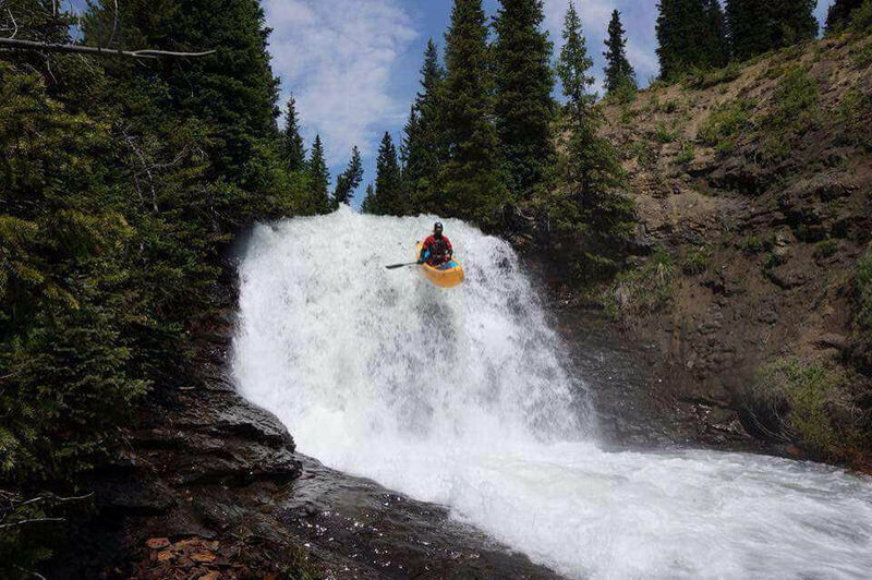
- they come to paddle Daisy Creek (i.e., Poverty Gulch), the Slate River, and the Upper East
River. Intermediate paddlers flock to the Lower Taylor River and those looking for awe-inspiring
views travel farther upstream to the Taylor River above Taylor Reservoir. More adventurous
visitors hike their boats miles into the Dark Canyon to paddle Ruby Anthracite Creek and the
mainstem Anthracite, one of the more unique and remote paddling adventures in Colorado. In the
Uncompahgre Forest, paddlers travel to the headwaters of the Uncompahgre and the headwaters of
the San Miguel for high-challenge and incredibly scenic paddling experiences. As paddlers, we
need to help the Forest Service understand the unique experiences that all these rivers have to
offer to those of us seeking tranquility and adventure.
In your comments to the Forest Service, we encourage you to include the following:
• Thank the Forest Service for determining Oh Be Joyful Creek Segment 1B to be Eligible and
for recognizing its paddling ORV and for determining Segments 1 and 2 of the San Miguel River to
be Eligible with a paddling ORV.
• Encourage the Forest Service to expand the Eligibility Study to include ALL free-flowing
rivers with at least one ORV
• Encourage the Forest Service to reference American Whitewater’s National Whitewater
Inventory when conducting Eligibility Studies
• Share your paddling experiences on the GMUG’s rivers, including details such as the
character of the river, personal stories, why you love to paddle the river, if you travel a far
distance to paddle the river, and any additional knowledge about the river’s scenery,
geology, and any other attributes.
• Remember to thank the Forest Service for considering your comments and for all their hard
work
We only have until March 22 to submit comments on the Draft Eligibility Study - so please act
now! Follow this link
to check out the Forest Service’s Wild and Scenic Story Map and online comment tool
and read the full Draft Eligibility
Study here. You can also email your comments directly to Brittany Duffy, the acting Forest Planner.
Finally, American Whitewater is soliciting photos for each of the river segments in the GMUG.
Having a robust inventory of the GMUG’s rivers will help us advocate for their protection
in the Forest Plan. Please send photos with photo credit, river name, rapid name, and any other
useful information to kestrel@americanwhitewater.org.
Photo of Matt Haughee by Josh King: Big Woody falls on Daisy Creek
