The Puyallup River drainages includes the White, Carbon, and Puyallup Rivers which originate off the slopes of Mt. Rainier, Washington's tallest mountain. All of these rivers offer whitewater boating opportunities that serve a range of skill levels form beginners to experts.
White River
 The White River flows off the northern slopes of Mt. Rainier and through public lands before passing into the White River Tree Farm, purchased by the Muckleshoot Tribe in 2013. Vehicle access to river access sites was previously available in the tree farm but now you must either use access points upstream or hike out. The Army Corps of Engineers' Mud Mountain Dam regulates flows at the western edge of the tree farm and then cuts through a gorge before it emerges downstream near the town of Buckley. Here a diversion dam redirects some of the flow to Lake Tapps. Puget Sound Energy operated a hydropower project at the outlet for Lake Tapps. After determining that it would not be cost effective to operate this project, PSE made the decision to sell project facilties and lands. This includes 10 miles of undeveloped river that provides valuable habitat in the Puget Sound lowlands that has long been a target for conservation.
Carbon River
The Carbon River Valley is the western gateway to Mt. Rainier National Park. American Whitewater has been a supporting partner in efforts to expand the boundaries of the park to protect the river in the vicinity of the put-in for the Upper Carbon near Fairfax. Land from willing sellers was obtained to provide long-term protection for this important wildlife corridor. The Carbon River emerges from its dramatic gorge, one of the most spectacular in the region, at the end of 177th St. Unfortunately the historic river access has been marked for no parking. This access point also serves those interested in the class II run that continues down to Orting. American Whitewater has worked to improve public access to this river which have declined over time.
Puyallup River
The Puyallup is the next drainage south of the Carbon and emerges from the remote western side of Mt. Rainier. A few explorers have hiked past the washout on the old west side road in Mt. Rainier National Park to travel down the Puyallup while others have paddled down the Mowich. Outside the Park, all vehicle access to the river is by private logging roads and although it was once possible to gain access with a $13 pass from Champion, the rates have gone up considerably with new ownership. The river cuts through the same geology as the Carbon and an impressive bedrock gorge that ends at Electron, the site of a privately owned hydropower project. This project is not licensed by FERC and unfortunately that means no public access is provided. Additionally the hydropower project, previously owned by Puget Sound Energy and then sold to Tollhouse Energy, has significant impacts on salmon and steelhead living in the watershed that are protected under the Endangered Species Act. American Whitewater took the operator to federal court to force compliance with environmental laws that protect river health. Other parties have taken action on water quality issues with the project. Downstream of the powerhouse the river flows through more private lands and additional public lands that have been fenced off. Significant access has been lost along this river and our local volunteers are continuing to explore opportunities to restore access at key points.
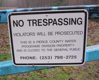
Significant opportunities exist on all three of these rivers to achieve conservation gains but we are also searching for opportunities to provide appropriate public access which has been lost over the years. We are particularly concerned that not only private but public lands have been fenced off, severely degrading the quality of recreational opportunities that were once available.
 River access blocked on public lands as well as private lands
Other Organizations Working on Conservation and Recreation in the Watershed
Forterra
The Mountaineers
Foothills Rails-to-Trails Coalition
